Map of the Canadian Rockies
Seven parks in Alberta and British Columbia, the towns you can base yourself in, the roads that tie them together and the lakes people come for, with each publisher's distances and the page of this site that covers each one.
UNESCO’s Canadian Rocky Mountain Parks are seven parks that touch one another: Banff, Jasper, Yoho and Kootenay national parks, and Mount Robson, Mount Assiniboine and Hamber provincial parks in British Columbia. Together they make one World Heritage Site, inscribed in 1984 and extended in 1990 to take in the three provincial parks. UNESCO gives the whole as 23,069 km², about 400 km long and up to 100 km wide. Parks Canada also lists Waterton Lakes, which is not in the World Heritage Site, among the parks in the Canadian Rockies.
Banff and Jasper national parks are in Alberta, Yoho and Kootenay in British Columbia. The nearest city to Banff is Calgary: the town of Banff is 128 km west of it by the Town of Banff’s figure, and Calgary International Airport, the closest airport to Banff National Park, is 144 km from the town by Travel Alberta’s. Jasper is 288 km north of Banff by road (Travel Alberta) and 370 km west of Edmonton (Parks Canada).
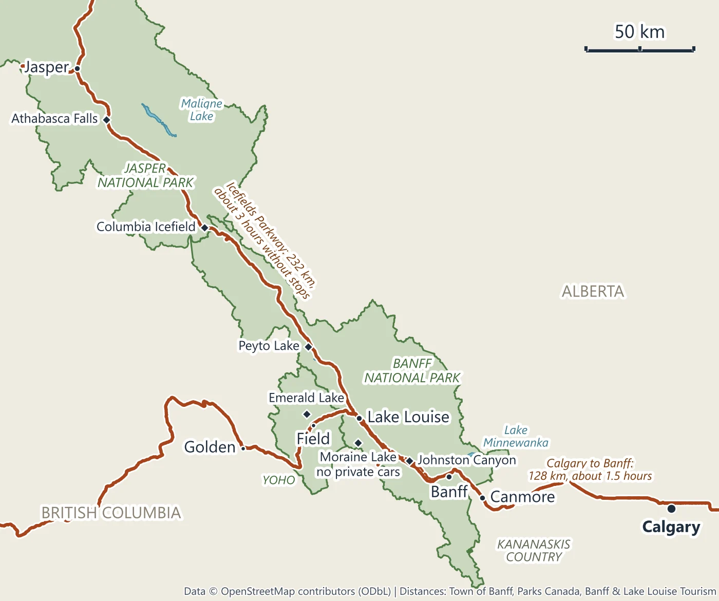
The parks
| Park | Province | Area | Created | What is in it | Pages here |
|---|---|---|---|---|---|
| Banff National Park | Alberta | 6,641 km² | 1885 | The town of Banff, Lake Louise, Moraine Lake, Lake Minnewanka, Johnston Canyon, and the Icefields Parkway as far as Sunwapta Pass | Banff, Lake Louise, Moraine Lake, Johnston Canyon, Lake Minnewanka, Icefields Parkway |
| Jasper National Park | Alberta | 11,228 km² | 1907 | The Parkway north of Sunwapta Pass, the Columbia Icefield at the park’s southern end, the town of Jasper, Maligne Lake | Columbia Icefield, Jasper |
| Yoho National Park | British Columbia | 1,313 km² | 1886 | Field, Emerald Lake, Takakkaw Falls, the Natural Bridge, the Burgess Shale | Yoho |
| Kootenay National Park | British Columbia | 1,406 km² | Highway 93 South, the Banff-Windermere Highway | not covered | |
| Mount Robson, Mount Assiniboine, Hamber | British Columbia | Provincial parks in the World Heritage Site | not covered |
Sources: Parks Canada for the areas and dates; UNESCO for the World Heritage Site.
Parks Canada calls Banff “Canada’s first national park” and Jasper “the largest and most northerly of the Canadian Rocky Mountain national parks”. Yoho has “28 peaks over 3 000 metres in height”, and its Burgess Shale fossil beds, which UNESCO calls “one of the most significant fossil areas in the world”, can be visited only on guided hikes. Kananaskis Country is provincial land, not a national park, run by Alberta Parks and more than 4,000 km² in size; the Canmore page covers it with the town.
The towns
| Town | Where | Residents | Worth knowing |
|---|---|---|---|
| Canmore | Outside the national park, 22 km east of Banff (Explore Canmore) | 15,990 (2021 Census) | No park pass needed for the town itself |
| Banff | In Banff National Park, 128 km west of Calgary | 8,305 (2021 Census) | A hospital, by Parks Canada’s list of services |
| Lake Louise | In Banff National Park, 55 km west of Banff | “500”, a Parks Canada round figure | Travel Alberta calls it “Canada’s highest alpine community”; a medical clinic, a grocery store and gas |
| Field | In Yoho National Park, 30 km from Lake Louise | Home to “almost all human residents of Yoho National Park” (Parks Canada) | |
| Jasper | In Jasper National Park, 288 km north of Banff | 4,738 (2021 Census, before the 2024 wildfire) | VIA Rail serves the town |
The 2024 wildfire destroyed about 30% of the town of Jasper’s structures, and most of the park is open in 2026; Jasper after the wildfire sets out what changed.
Calgary is the gateway: the closest airport to Banff National Park, with scheduled coaches to Banff run by private operators and no passenger train. Where to stay depends on the trip. Condé Nast Traveler, in a piece presented by Destination Canada, says “most visitors choose the town of Banff as their home base”; Lonely Planet points budget travellers to Canmore; Banff & Lake Louise Tourism’s own itineraries split the nights between Banff and Lake Louise. Banff or Jasper weighs the two parks.
The roads
- The Trans-Canada Highway (Highway 1) runs west from Calgary past Canmore to Banff, on 55 km to Lake Louise, then crosses Kicking Horse Pass, in Parks Canada’s words “the highest point on the Trans-Canada Highway”, on the way to Field in Yoho. It is one of two roads you may drive through Banff National Park without a park pass, and only if you do not stop.
- The Bow Valley Parkway (Highway 1A) is a 48 km paved alternative between Banff and Lake Louise, with Johnston Canyon on it, 25 km from Banff. From 1 March to 25 June no one may travel its eastern 17 km between 8 pm and 8 am.
- The Icefields Parkway (Highway 93 North) runs 232 km from Lake Louise to Jasper by Parks Canada’s figure, with services only from early May to mid-October. Banff to Jasper goes stop by stop.
- Highway 93 South, the Banff-Windermere Highway, crosses Kootenay and is the other road you may drive through Banff National Park without a pass if you do not stop. British Columbia’s winter-tire rule applies on it from 1 October to 30 April.
- Highway 11 leaves the Icefields Parkway at Saskatchewan River Crossing, toward Cline River and Abraham Lake, outside the national parks.
- Highway 16 passes Jasper; the turnoff for Maligne Lake Road is 3 km east of town.
The Bow Valley Parkway and the Icefields Parkway need a park pass even if you never stop. Some side roads have rules of their own. Moraine Lake Road, about 14 km from the community of Lake Louise, has been closed to private cars all year since 2023. Yoho Valley Road, to Takakkaw Falls, is open only from mid-June to mid-October. Maligne Lake Road runs 48 km from the turnoff to the lake (Pursuit’s figure), with single-lane road works until the end of October 2026.
Where the lakes are
| Lake | Park | Where | Getting there | Page |
|---|---|---|---|---|
| Lake Louise | Banff | At the top of Lake Louise Drive, 4 km from the community | Car (the lakeshore lot cost CA$42 a day from 15 May to 12 October 2026), Parks Canada shuttle in season, Roam’s 8X from Banff all year | Lake Louise |
| Moraine Lake | Banff | About 14 km from the community of Lake Louise | No private cars; shuttles and licensed tours, June to mid-October only; not reachable in winter | Moraine Lake |
| Lake Minnewanka | Banff | About 20 minutes’ drive from Banff (Pursuit) | Car or tour; the 2026 cruise season runs to 12 October | Lake Minnewanka |
| Vermilion Lakes | Banff | Along a 4.3 km road open all year, part of the Banff Legacy Trail | Car, bike or on foot | Banff |
| Bow Lake, Peyto Lake | Banff | 37 km and 43 km north of Lake Louise on the Parkway | Car or tour | Icefields Parkway |
| Emerald Lake | Yoho | 10 km west of Field | Car or tour; “There is no public transportation in Yoho National Park” | Yoho |
| Lake O’Hara | Yoho | At the end of an 11 km road closed to cyclists | Parks Canada’s shuttle bus, seats by random draw (19 June to 4 October in 2026) | not covered |
| Maligne Lake, Medicine Lake | Jasper | Along Maligne Lake Road | Car, Maligne Adventures’ shuttle (1 June to 20 September in 2026), or tour | Jasper |
| Pyramid Lake, Lake Annette | Jasper | Near the town of Jasper | Car, or the town’s buses; Pyramid Road is open all year | Jasper |
| Abraham Lake | Outside the parks | Off Highway 11, near Cline River | Winter tours from Calgary, Canmore and Banff visit its ice bubbles from December to March, weather permitting | Icefields Parkway |
| Grassi Lakes | Kananaskis (provincial) | Canmore Nordic Centre Provincial Park | Car, with a Kananaskis Conservation Pass (CA$15 a day) to park | Canmore |
Parks Canada calls Maligne Lake “the largest natural lake in the Canadian Rockies”, 22 km long, and says Medicine Lake “disappears” in fall and winter, “becoming a mudflat”. Lake Minnewanka’s “largest lake in Banff National Park” is the operator’s line; we found no Parks Canada page that says so.
Every area page on this site
- Banff: the town, the Banff Gondola up Sulphur Mountain, and tours from horse rides to stargazing.
- Lake Louise: the lake, its parking and shuttles, and the full-day tours that add Moraine Lake and Emerald Lake.
- Moraine Lake: the shuttle tours and sunrise trips, since private cars cannot drive there.
- Yoho: Emerald Lake, the Natural Bridge and Takakkaw Falls, across the provincial line in British Columbia.
- Johnston Canyon: the canyon walk, the winter ice walk, and the closure from 13 October 2026.
- Lake Minnewanka: the cruise, a helicopter flight over the lake and the stargazing tours.
- Icefields Parkway: the day tours along Highway 93 North, and the one-way trip to Jasper.
- Columbia Icefield: the Ice Explorer and Skywalk ticket, a guided glacier hike and the day trips from Banff and Calgary.
- Jasper: Maligne Lake, the SkyTram, wildlife tours and an easy raft trip on the Athabasca River.
- Canmore: rafting, river floats and helicopter flights, just outside the park.
- Calgary: airport shuttles to Banff and day trips from the city.
Questions people ask
What is so special about the Canadian Rockies?
UNESCO’s statement on the site stresses its size and the fact that “over 95% of the area is legally or administratively maintained in a completely natural condition”. The parks also hold the Burgess Shale and the Columbia Icefield, “the largest icefield in the Canadian Rockies” in Parks Canada’s words; from the top of the icefield’s Mount Snow Dome, meltwater flows to the Pacific, the Arctic and the Atlantic. And Banff, founded in 1885, is Canada’s first national park.
What city is closest to the Rocky Mountains in Canada?
Calgary, for Banff: the town is 128 km west of the city, and Calgary International Airport is the closest airport to the park. For Jasper, Edmonton is 370 km away by Parks Canada’s figure, and Calgary 404 km.
What is the best way to see the Canadian Rockies?
That depends on whether you drive. With a car you need a park pass for any stop in the national parks, and you still cannot drive to Moraine Lake. Without one, Roam’s buses link Canmore, Banff and Lake Louise, but there is no public transport in Yoho and no Roam route north of Lake Louise, so the Icefields Parkway and Yoho are tour days. VIA Rail serves Jasper, and the Rocky Mountaineer, a daylight tourist train with hotel nights in Kamloops, runs from April to October. Calgary to Banff and Vancouver to Banff cover the ways in.
How many days are enough for the Canadian Rockies?
Parks Canada’s “Banff and Jasper: the ultimate duo” itinerary takes seven days and 945 km from Calgary and back: three days around Banff and Lake Louise, one on the Icefields Parkway and three in Jasper. The Banff itinerary covers one to five days in Banff National Park.
What is the best time of year to visit the Canadian Rockies?
There is no single answer. Visits peak in July and August, by Parks Canada’s counts; the high lakes thaw in late May or early June, depending on the source; and the ski areas open in November. The best time to visit Banff goes month by month, and Banff in winter covers the cold season.
How far apart are Banff and Jasper?
288 km, by Travel Alberta’s figure, about 3.5 hours without stops by Banff & Lake Louise Tourism’s. Parks Canada’s own figures add up to 287 km: 55 km to Lake Louise, then 232 km on the Icefields Parkway, which needs winter tires or chains from 1 November to 31 March. Banff to Jasper covers the drive stop by stop.
Settled on an Area?
Each tour's calendar shows the dates it is actually running, with the price and that tour's cancellation terms. Most tours listed here can be cancelled for a full refund up to 24 hours before, and three need two or three days' notice; the Pursuit Collection admission tickets for the Banff Gondola, the Lake Minnewanka and Maligne Lake cruises, the Columbia Icefield and the Jasper SkyTram have no free cancellation.
Compare the Tours, Area by Area